240 Miles in the Arctic National Wildlife Refuge
Shannon Kuhn and I spent 22 days traversing the Arctic National Wildlife Refuge, from the Haul Road to Kaktovik. We were joined by some friends along the way.
Words and photos by Will Koeppen

The Trans-Alaska Pipeline snakes its way south from Prudhoe Bay. Periodic bends in the pipeline protect against tectonic movement as well as thermal contraction and expansion. The pipeline is relatively warm which melts the snow below it, but the anchored supports are thermal radiators designed to move heat out of the subsurface and prevent thawing of the permafrost that supports the pipe.
My friend, Amy Downing, was killed in an avalanche on January 21, 2017. Amy was a powerful personality, and had a habit of nagging until her friends followed her into the backcountry. I was already toying with the idea of doing a long traverse in the Arctic National Wildlife Refuge (ANWR), and it suddenly seemed fitting to follow a route that Amy had done in ANWR with a group of friends two years prior.
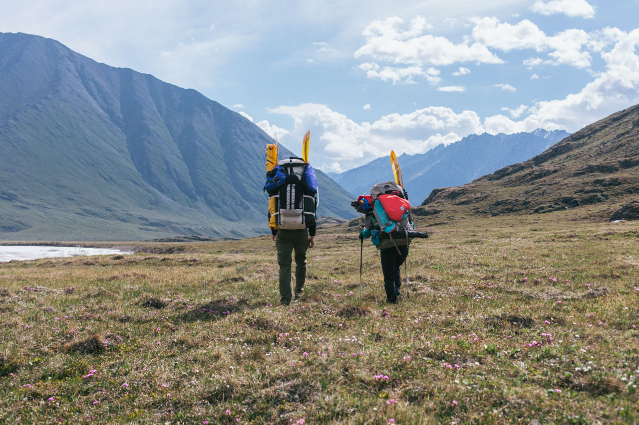
Shannon Kuhn and I planned and executed the 230-mile traverse within the Arctic Refuge from June 10 to July 2, 2017. Brian Olsen and Catherine Bodry joined us for the first ten days of the trip, and our route interwove with that of two other friends, Luc Mehl and Sarah Histand.


Pump Station 3 to the Marsh Fork
We started our trip in Deadhorse, Alaska, a dust-covered outpost of hangers and transfer stations. An Arctic logistics company (70°North) picked us up from the airport, and shuttled us and our gear south down the Dalton Highway. Built and maintained for the oil industry, the haul road goes from Fairbanks to Prudhoe and became the main trunk for nearly all goods that head into the Arctic, which are trucked to Deadhorse and then flown to the villages. The 110 mile road trip took 4+ hours due to constant (but typical) maintanance on the gravel road.
We got dropped off near Pump Station #3, and our driver, Doug, waited for us to all safely cross the Sagavanirktok River. We used two rafts to shuttle the four of us and our gear across, and then we made one last crossing to give Doug one of the packrafts so we wouldn't have to carry it. We collected ourselves on the far side of the river, checked the map one more time, put in a waypoint, and began walking.


The Ribdon River Valley was wide with good visibility and minimal tussocks. I.e., pretty easy going. Luc had relayed Ed Plumb's assessment, who said "It's like mall walking." The main hazard was the sun on never-ending blue sky days. I got a little toasted on our first day and had to retreat to long sleeves and buff over the ears. I was well prepared for rain, but the Arctic sun almost never faltered over the course of our trip.
It almost seemed a little too easy at times. The one thing that kept us from pouring on the miles was navigating sections of wide, cloudy river crossings and/or aufeis. The river wasn't steep or fast, but the icy thigh- to waste-high crossings still felt strong, and one day we had ~20 wades through the braids. The aufeis was riddled with meter-deep channels, slushy spots, and surface melt features. An occasional "BOOOM" would echo through the valley, letting us know it was in active breakup. But it was neat to see willows' catkins poking up through all the ice. We camped on the bluffs above the ice and had great views across the valley.


The first three days of the trip had cool temperatures, no bugs, and a lot of water. Higher up on the Ribdon on days 4-5, the river dove underground leaving behind wide, hot, and completely dry gravel bars. We scouted up side valleys to look for small water sources and became more careful about planning camping spots. We saw a caribou, one bear (moving fast away from us), and a lot of birds on their nests. We also saw evidence of an arctic fox — distinctive teeth marks in one of our food bags that had been dragged off the bluff overnight.


On June 15th, 5 days after we started, we reached the top of the Ribdon. Jellyfish clouds hung overhead but didn't do anything to diminish the sun. The pass wasn't steep, and the water was once again above ground, turning the pass into field of flowers.

Jellyfish clouds, or Altocumulus Castelanus, hang over the top of the Ribdon River Valley on June 15, 2017. These clouds form when a pocket of moist, condensing air gets trapped between two layers of dry air that don't support precipitation. The overriding layer stops further upward cloud formation, and the lower layer evaporates the precipitation (virga) before it can reach the ground.
We descended pretty steeply following a narrow stream bed. The stream cut across a lot of interesting geologic layers and coral, lamp shells (brachiopods), clams, and snails were littered everywhere. Catherine began a lifelong obsession with preserved spirals. A small side stream brought in water the color of rust from acid rock drainage somewhere above. We filled up with water just above the stained rocks.


We camped on the Ivishak River, at the edge of big mountains. The next morning Shannon poked her head out of the tent and announced that we should pack up before breakfast. I was vocally skeptical, but I included a photo of the face she made when our gear was packed and it started to snow.

We had given up on trying to keep our feet dry, but crossing the Ivishak in the morning snow still felt icy. We climbed the valley wall on the other side and the white-capped mountains got prettier and prettier as we ascended. Shannon and I talked about our next trip, maybe something in a Nordic country around the winter holidays: skiing hut to hut, Christmas markets, hot and hearty meals — sehnsucht and the desire for hygge was in the cold Alaskan air that morning.


We built in a weather day, but it had so far been so nice that we just took the day "off". Catherine used it to explore the base of the Continental Divide, Brian spent it birding throughout the valley, and Shannon and I climbed up a side gully towards one of the layered peaks.


Initially, she didn't like my route, which followed a thin sheep trail above a rocky gully, but afterward she said, "from now on I know to trust the sheep!" From the top we had commanding views of our camp and the valley.


When we got back down, Brian revealed that our friend, Tara Wheatland, had packed us a nalgene filled with Manhattan mix. It was the only time that alcohol sounded even remotely appealing on our trip. That night I got up to let out the booze around 2 am and saw the low-angle sun pouring across our campsite. It only lasted about 30 minutes, but I couldn't stop watching the shadows move.


Energized from our layover day, we sent a message to Luc and Sarah (who we knew were hiking fast behind us) telling them our plan to camp at the top of the Marsh Fork of the Canning River that evening. Then we hiked out of the large valley and into a narrow channel with easy walking along a small, clear stream.


On the far side of the pass, the stream was a little larger, and the valley was much narrower. Occasionally, the channel in which we were walking was squeezed between cliff faces and often filled with snow and ice formations. Navigating the pinch points required slowly climbing around them on scree or choss.


As the day grew longer the water level rose, and after a serious discussion (closed and re-opened twice) we decided as a group to climb a talus slope out of the channel and explore our options. We emerged onto a beautiful, flat, grassy wedge that looked down the valley and across to a five-tiered waterfall. About 20 minutes after we arrived, Catherine saw Luc and Sarah further down in the channel and we whistled them back. After an intense day, it was really nice to see familiar faces. That night was the first time we had mosquitoes. Knowing what we know now, it's funny to think we thought they were bad.


As a group of six, it was sometimes an awkward stand-off to see who would be the first to start hiking, but it was fun and instructional to see how Luc and Sarah camped, hiked, and navigated the terrain. For example, they didn't carry water while we hiked down the stream, instead just using a nalgene to scoop up water whenever they wanted. I felt too used to my old habits.


Our canyon dropped into a wide valley, the Marsh Fork of the Canning River, and it was back to easy walking over gravel bars and through shallow streams, fields of saxifrage, and pockets of willow. We chatted about satisfaction in our jobs and lives, and we shared ideas about how to use our experiences in ANWR and what kind of statements we wanted to make. Luc was working on a dance video, and we found a large boulder and he filmed us dancing on it.


When we saw our destination in the distance, a flat stretch of grassy land accommodating a short runway, we stopped to wash in the stream. Then we camped near the strip which also hosted a few guides and their groups. For Catherine and Brian, it was their last night in the backcountry so we set up our tents close by and read the final chapters of our group book aloud.
From Ready Player One: "Going outside is highly overrated."
Marsh Fork to the Hula Hula River

On June 20th, around noon, a bush plane arrived to trade giant duffel bags of food and gear for Catherine and Brian. It felt strange to see them excited to leave while Shannon, Luc, Sarah, and I were preparing for two more weeks in the backcountry. We watched them fly out and then stuffed our packs.
Luc had promised to cook us a "heavy" lunch flown in by the plane: pulled pork with rice noodles, coconut and red curry sauce, fresh ginger, cabbage, and apples. We couldn't finish the pie he brought and didn't even touch the brick of cheese.


Throughout the day, thunderclouds built and hung above the mountains to the south. And even though their bags were completely packed, Luc suddenly said, "I think we might pitch the tent."
"Really?" Sarah asked.
Shannon and I were ready to go, so we said our goodbyes and lumbered through the brush towards the river hand-carrying our luxury drop items — bottles of V8 and an apple left over from lunch. Ten minutes later the sky split with a "CRAKOOOOOOOOM", and we scrambled to pitch our tent in the driving wind and rain, throwing our stuff and ourselves inside. I had to yell over the storm, "From now on when Luc Mehl gets in his tent, we're getting in ours too!"
The clouds softened around 4:30 pm, so we put on our drysuits, repacked our gear in our rafts, and floated down through the aufeis and out of the storm.

After hiking 10-12 miles nearly every day, it felt crazy to cover 28+ river miles down the Marsh Fork in a single day. The terrain flew by, which was sometimes a little disappointing because we would have had time to admire it more while walking. The early part of the river was a network of shallow, braided streams, and we played the game of "find the deepest branch." In the afternoon, it became a single channel filled with boogie water for miles — the roughness surprised us both. The Marsh Fork was silty and brown, but we filled up with fresh water from smaller incoming streams or from aufeis surface flows. After the long day, we pulled our boats out where the Marsh Fork entered the Canning River proper. As we set up our tent and cooked dinner, we watched yet another storm roll in and out in the West.


June 22nd was a weird day. As we were packing up our tent, a young caribou walked across the aufeis on the river to stand 100 yards away from us and stare. I thought about trying to scare it away because a caribou used to humans sounds like a caribou in the freezer, but it eventually wandered back across the ice. We walked up the Canning River, and somehow Shannon lost her can of bear spray without either of us noticing. We spent an hour and a half looking for it before giving up. We tried to wade across the Canning River but after a long, cold attempt realized we'd need to inflate the boats.


When we finally got into Franklin Creek valley, it was a green mix of knee- to thigh-high blueberry bushes, tall and swampy tussocks, and incised stream channels that dropped us 10 ft down into 15 ft-high willows, which I was sure were filled with bears. Franklin Creek itself was in a deep trench so we only rarely saw it. The back of the valley toward which we walked was black with rain nearly the entire day. Shannon started to have nerve tweaks in her back and was at a pretty low point, when suddenly a bright, supernumerary rainbow popped out of the clouds. Shaking off the slog, she exclaimed, "This day will now be known as Quadruple Rainbow Day!" (Science note: there are actually five interference bands plus the secondary rainbow.) In the blueberry brush, we found one of the softest, most comfortable camping spots of the whole trip.


Franklin Creek was a 20-mile long, tussock-filled marsh. We came to see the blueberry patches as a refuge because, although brushy, the ground was at least solid underneath. Nearing the top of the valley, the brush was a little less thick and the river channel came up to meet us.


We climbed out of Franklin Creek by following a few caribou tracks as they worked their way up into a perched valley. The tracks climbed rocky slopes, followed a gravelly stream, passed a small summit lake, and then dove down a long, steep pitch through talus and saxifrage.


We followed Carnivore Creek from a multi-tiered waterfall near its source as it alternated between meandering and vegetated flats and rock-filled step-downs. Further along, the caribou tracks multiplied a hundred-fold, and the green landscape looked like it had been cultivated by their hooves. The valley was filled with bright blues, greens, reds, and yellows, and the colors made us care less about how marshy it was. The deep mud there was an earthy red that didn't wash out, and occasionally we'd see the sheen of oils on the surface — probably anaerobes working their magic below the surface. The mosquitoes started to come out too, but it was still windy enough that they kept getting blown away.


Carnivore Creek flows into Lake Peters and then Lake Schrader, each one is about four miles long. When our friends did this trip two years ago, some of them paddled across the lake, and a few researchers staying at a field station there boated out to meet them. Shannon and I were both dreaming up all the science questions we'd ask at the research station to endear ourselves until they would (of course) kindly offer us some freshly-made oatmeal cookies.


When we came into view of the first lake though, it was covered in ice. The ice was too thin to walk on, and it was pushed up onto the shore in places, so it was a long, soggy walk on the lake's edge. The research station was boarded up, and a weathered plank dinghy — the same one that met our friends? — was stowed outside, but it didn't look seaworthy.


It had been five days since we left Luc and Sarah, and it felt really strange to come upon human structures only to find them deserted. When we got closer, we heard a scratching noise, like an awl digging into old wood. A porcupine was making a meal of the outhouse.


Past the station was stretch of open water near the lakeshore, and since it had started to rain anyway, we inflated the boats. Shannon was excited to use different muscles and take a break from her pack, but paddling a packraft against a stiff wind on flat water for the next few hours was probably my lowest point of the whole trip. I was cold and wet and surprisingly angry about it. Progress was achingly slow, but just fast enough that the path following the shore might have taken longer. Maybe?


I cursed a lot into that wind on Lake Peters, and it was the first time I wished for my headphones and some music so I could plug in and escape. When we crawled our way through the strait and into Lake Schrader, I was so happy that it was choked with ice.

The sun was blazing when we woke up, and we took a long morning to dry out our gear, reapply leukotape, and take a peek at a nearby cabin. The sign outside said "Rexford's". Then we climbed up and along the bluff to the south and east of Lake Schrader.


The last few days of travel had aimed us almost straight north, taking us out of the steep, rocky mountains and into rolling, tussocked hills. We crossed rusty-colored Karen Creek and made our way across the highlands. Luc and Sarah texted us with the location of our final food cache, and we were trying to decide what to do with our last layover day, when we realized that the end of our trip had suddenly came into view. To me, it had the same quality as the last few days spent with a long-distance partner - when the fierce urgency to enjoy every dwindling moment feels overwhelming. It also made me realize that my shorter backpacking trips are all end game - planning for the return even as I leave the trailhead. The length of this trip had, for a while, helped me to forget about ever having to go back.
That evening, we camped on a plush, moss-covered peninsula on an alpine lake above Katak Creek. There were bugs but they didn't bite humans and walking barefoot felt like being in a bouncy house. Shannon took her boat across the lake, and then together we considered how we wanted to use our last week in the Arctic Refuge.


It was literally all downhill from here. We left our camping spot at the lake and quickly descended towards Katak Creek. We were following caribou signs again, and it was neat to see the herd's tracks converging and diverging like a river over the natural features of the landscape.


A little bit further and we were there, the Hulahula River. We searched for and found our last food stash — a bear bag tied into a tall willow tree. A friend of Luc and Sarah's, Sarah Tingey, had completed a trip down the Hulahula earlier in June, and she had graciously flown a few days worth of food for our two teams to an upriver bush strip. After we left them during the thunderstorm at the Marsh Fork, Luc and Sarah had taken a higher route through the heart of the mountains, picked up the drop, floated it down river, and stashed our portion at the end of Katak Creek before continuing towards the Okpilak. It had been long enough since I packed that bag that it was a surprise to see what was in it.
The Hula Hula River to Kaktovik
Arriving at the Hulahula felt like a major milestone. It was a straight shot out of the mountains from here. I was also carrying some ashes that were once part of my friend Amy's body, and it was my plan to scatter them in the Hulahula, a bit further down river. Amy Downing was my inspiration for planning this particular trip, and she had done a similar route two years ago. She loved paddling the Hulahula, and it moved me to think that we could scatter her ashes and then float with her just a little bit longer towards the Arctic Ocean. Even though it was only early afternoon, there was a strong wind blowing up river. We opted to set up the tent, read books, take a nap, enjoy the afternoon, and get up very early the next morning to begin our float.


We got up at 4:30 am to take advantage of the lack of wind. The water was fast but mellow, and we floated by a large, guided rafting group that was just staggering out of their tents. We had gotten mixed reviews about the difficulty of this section of water, but our friend Mary Krusen had told us to be prepared for waves that seemed larger than the "splashy Class II" description that fit the rest of the river. I was glad she had warned us.
To finally exit the Brooks Range, the Hulahula slices through one last stretch of mountains by zigzagging three times through sections with high, layered walls, and each cut is filled with rapids. I paddle quite a bit, but I was surprised by how nervous I felt to be in remote whitewater, and I was happy that Shannon and I had both gotten a lot of time on rivers and creeks in the spring. We scouted a few of the rapids from shore, discussed our lines, and took it slow through the canyons. It was a beautiful morning.


At around noon we pulled onto a gravel bar near a fresh water source among low, grassy hills. We relaxed, ate some of our extra food, and watched jets criss-cross the sky over the North Slope. A lonely caribou came and stood on a nearby patch of ice for a few hours. Thunderstorms slowly built over the mountains behind us just to dissipate overnight.


Shannon was good about reminding me that we should scatter Amy's ashes soon. A few weeks before the trip I went to Amy's parents' house, met with her mom, and talked to her about our trip. She gave me a few ounces of ashes in a transparent purple film canister. I added some extra protection using duct tape patterned with bright, psychedelic flowers that I knew Amy would have liked. And then I carried a portion of her bones on my back for 20 days.
I had put them in the bag with my toothbrush so I'd be reminded every day that she was with us. I knew that it was the right time — we were well down the Hulahula but still within sight of the mountains, but it was suddenly really hard to give them up. They were the only things I had of hers.
We got in our rafts, went down the river a little ways, and beached ourselves on an island in the faster flow. For the whole trip I had been thinking about what I'd say as I released them, but all I could choke out at that moment was, "I miss you babe."

We floated 30 miles that day as I blinked away the saltwater that somehow kept getting into my eyes. We passed an off-kilter house and threaded our way through shallow channels between collapsing aufeis and permafrost. Shorebirds and salty chill started to fill the air. We ended the day 15 miles from the Arctic Ocean because a guide told us that polar bears don't forage more than 10 miles from the coast. When we got back I read that researchers have commonly found polar bears traveling 20-30 miles inland.


The next day, the wind was pounding from the east at 25 knots, and we had to work hard against it to get in the far eastern channel of the Hulahula. The birds that were making attempts to fly weren't having a great time of it either. We pulled our boats out of the water a few miles from the ocean and put our heads down to drag our loaded boats the 1/2 mile to the Okpilak River, which we also crossed.

Our original plan had been to float out the Okpilak to Arey lagoon and then walk the barrier islands back towards Kaktovik, but I had a few-day-old sea ice report from a co-worker that suggested there might be compacted sea ice up against the islands. The land route also made me a little nervous because the 12-mile distance was almost entirely designated as swamp on the USGS topo. In the end we decided to take the land route, which I think was the right decision for our days of travel because of the strong winds. (Luc and Sarah would take the barrier island route two days later, but the wind that day was ~5 knots from the north.) The eastern side of the Okpilak was an Eden of sandy soil covered in wildflowers and we reveled in taking off our drysuits for the last time.


Shannon wanted to put in a few miles towards Kaktovik so we continued into the wind. There were virtually no elevation features on the coastal plain so we navigated by the rectangular tundra ponds filled with dark water. The ground was drier than I was expecting, though still ankle-deep in spots. We set up our tent on a polygon surrounded by a water-filled ditch and hoped the wind would die down.

Our tent was veiled in mosquitoes. Were we really just wishing the wind would die down? Eating our day-food for breakfast in the tent, we dressed as if for rain and lurched into the clouds on a hot and sunny day. We walked east along the southern shores of three large tundra ponds filled with ducks, geese, and swans. Smaller birds sat on their nests, low and camouflaged, until we nearly stepped on them, then they'd scream off. One of the arguments I've heard about opening ANWR to drilling is that “there's nothing up there,” a statement that is obviously misinformed with regards to wildlife.


The map showed a “winter trail” and we turned north to follow it. At first there was no visible trail, but then we started to see signs of humans: ATV tracks, an old barrel, animal scat with pro-bar wrappers in it, and then a white tent on the horizon. The tent marked the end of the isthmus and we got there just as the eastern wind picked back up to a howl. We were grateful that it scattered the bugs, but it made for a tense, cold, and splashy crosswind paddle to ferry the 300 yards to Barter Island. We packed up our boats for the last time and followed a long line of wooden debris.


The first infrastructure we saw was Kaktovik's new town dump site, and we both agreed we should take our backpacking trash back home with us so as not to contribute to their limited space. We climbed up and onto the asphalt road and walked the 2 1/2 miles into town.


Around Town
We received a warm welcome in Kaktovik. We asked directions to the Waldo Arms Hotel and a young man said he was going there too and would walk with us. Peter was on the polar bear patrol, tasked with using ATVs, firecrackers, or other noisemakers to shoo away bears that wander into town.

Waldo's is one of two bunkhouses in town as well as a gathering place to get snacks, watch TV, or play cards in the dining room. While we mowed down cheesesteaks and curly fries, there was a steady stream of locals who came in for take-out fried food. No one wanted any part of the bowl of apples on the counter so I ate the last one. Waldos was staffed by Roger, Will, and Susan, and the latter two lamented the fact that the owner wanted them to paint the heavy front door dark brown instead of bright blue.
Susan said she already knew Luc and Sarah were coming into town —later we'd learn that she was also the RAVN ground crew and had the daily flight roster. We pitched our tent on the lawn, and I took a lovely evening walk around town.


The next morning Roger told me a little about his story and small town politics. Shannon and I climbed into the bus that Susan used to pick up and distribute supplies brought in by the plane. It hadn't arrived yet so she drove us the one minute "into town" to a pre-July 4th BBQ. I was nervous to participate in such a local event, but as soon as we stepped out of the bus a man jumped up to usher us toward the hot dogs, burgers, ribs, and potato salad. He told us that more (more??) was on the way.
When we got the call that the plane was arriving, a few people climbed back onto the bus with us: friends of the ground crew, enlisted helping hands, or people just curious about what might arrive. A few of them encouraged us to stay for the July 4th festivities, and we wished we had planned on it. We got to the runway and waited while a human train unloaded 600 lbs of watermelons from the plane, apparently donated to Kaktovik each 4th of July by Exxon Mobil.

On the flight out, I looked for Luc and Sarah walking across the barrier islands, but the angle from the plane window was wrong. They said they saw us fly over though.
We flew back to Anchorage via Prudhoe Bay and Barrow. It was hard not to contrast the landscape that we had just rafted and walked through to the industrialized, aerial view of Prudhoe Bay.

Since returning from our trip two months ago, I've become more familiar with the geography of the North Slope, read about oil production and exploration wells in Alaska, often tried and often failed to find relevant statistics, and talked to people about impacts of oil development on wildlife. There is a lot to learn, but I know that after our trip we're more able to contribute to a meaningful conversation about the Arctic Refuge.
I'm probably most surprised by the number of people who have been to ANWR and yet say that it's a "wasteland."

Acknowledgements
I feel lucky to have been led through this experience by my friend, Amy. As we hiked and floated, Shannon and I both wondered if her group had walked on this or that side of the river, if they chose the same campsites that we did, and what discussions about life they had. I know that some people like to be the first ones to do a long backcountry route, but in this case I feel really happy that we can share our experience with so many other people. In addition to Catherine, Brian, Luc, and Sarah, we had planning advice and so much encouragement from numerous people in Alaska from Amy's group including Matt Rafferty, Mary Krusen, Becky King, Tony Perelli and Sarah Heck. By proxy, we were also building off routes pioneered by Roman Dial, Brad Meiklejohn, and Ed Plumb, who have explored in and around ANWR many times and whose experiences and advice trickled down to us through countless other people. We're also indebted to our emergency contacts, Vikram Patel and Tara Wheatland, who followed our route and planned for the worst; our neighbor, Schawna Thoma, who called places in Kaktovik to nail down our lawn camp; my friend and co-worker, Brian Stone, who sent us a sea-ice report; and many old and new friends who gave us hints, tips, answers, and help to make this trip happen for us.
Amy was a great connector of people, and clearly that hasn't stopped.
